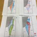
A Peaceful Partition
Posted by Ariel WarshawIn 7th Grade Humanities, students have been learning about the Middle East. As our final case study, we have been exploring the roots of the Arab-Israeli Conflict. After analyzing primary sources from early Zionist and Arab Nationalist thinkers, seventh graders were then shown an image of the UN Partition Plan that was adopted as Resolution 181. We talked about why some may have readily accepted it, while others were opposed to it.
Students were then divided into groups and provided with a number of maps of the region: Soil Quality, Water Resources, Population Distribution (1946), and Land Ownership (1945). After poring over these images, along with reading through key excerpts from relevant primary sources, the groups were tasked with creating their own “Partition Plan”. They had to consider a number of factors when making their plan: geography, history, population, land quality, location of cities, the legacy of WWII, and so on. Finally, students were given a blank map to draw out their proposals.
← Unquowa 5th Graders Take NYC! 3,2,1...Blast Off! →


